• Home
  • Products
    • Agricultural Drone
      • P150
      • P60
      • P100 Pro
    • AutoPilot Console
      • APC2
    • Smart Farm Solutions
      • FBV
      • FPDI
      • FPI
      • FC5
      • FS2 & FR2
    • Unmanned Ground Vehicle
      • R150 2022
      • R150 2020
    • Remote Sensing Drone
      • M2000
      • M500
  • News
    • News Centre
  • About
    • About XAG
    • CSR
    • Service
    • Contact Us
  • Become a Distributor
    • Apply Now
    • Distribution Network
        A Vast Field Captured In a Blink
        Watch
        With the fixed-wing VTOL design, XAG M2000 Remote Sensing Drone is developed for high frequency and high
        demand aerial survey tasks of multiple scenarios, which allows one person to map fields of 533 hectares in an hour¹.
        Equipped with XAG SuperX 4 Pro Intelligent Control System, the XAG M2000 is capable of accessing quality
        geographic data, which helps build up digital field maps stably and rapidly to facilitate production decisions.
        Accurate & Autonomous Flight
        RTK Centimetre-Level Positioning
        Automated Flight Planning
        Flexible Take-off and Landing
        Fixed-Wing VTOL Design
        Quick Release Body
        Sophisticated & Stable Imaging
        XCam 20MP Pro Gimbal Camera
        XCam 26MP APS-C Gimbal Camera
        XCam 20H Hybrid Gimbal Camera
        XCam 20M Multispectral Gimbal Camera
        Safe & Efficient Images Stitching
        Cluster Cloud Computing with Encryption
        Post Processed Kinematic
        VTOL For Flexible and Efficient Flight
        The quick assembly XAG M2000 can be immediately deployed for
        operations. The combination structure of multiple rotors and fixed
        wings allows flexible take-off and landing. 3 kg EPP fuselage plus the
        high-energy-density battery provide up to 90 minutes flight time and a
        range of 86 kilometers in a single flight.
        Maximum Battery Life²
        Maximum Flight Distance³
        Quick Assembly⁴
        Overall Weight⁵
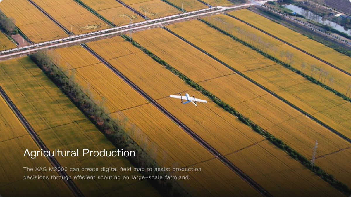
        Outsmart, Outperform, Outsprint
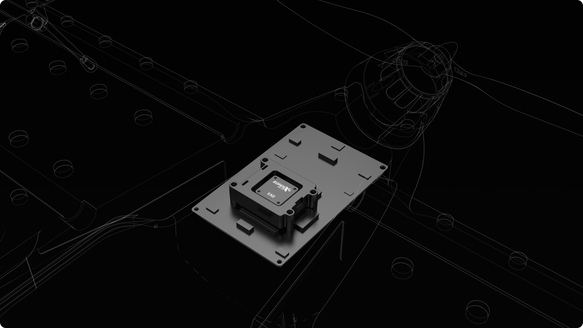
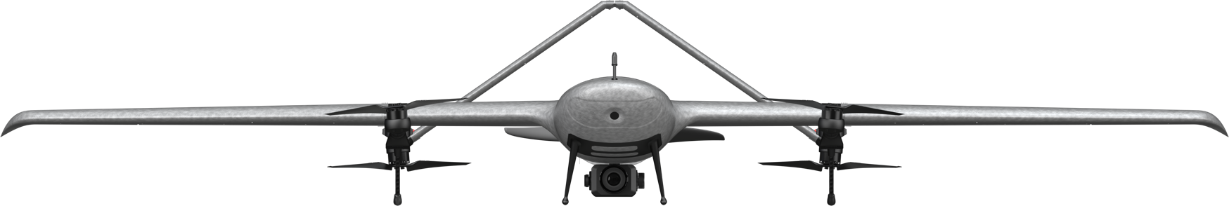
        The SuperX 4 Pro Intelligent Control System endows XAG M2000 the
        power of fully autonomous flight at cm-level accuracy while capturing
        high-resolution images. With a built-in emergency response
        mechanism, it monitors the drone’s flight status in real time, and
        supports quick swapping between multi-rotor and fixed-wing flight
        modes, ensuring flight safety and survey efficiency.
        Centimetre-Level Positioning
        Dual-Antenna RTK + Cloud Base Stations⁶
        Safe Flight
        3 x IMU + Emergency Response Mechanism⁷
        Stable Data Connection
        4G Network Transmission
        Seamless Trajectories
        Break-Point Continuous Flight
        Longer Battery Life, Higher Efficiency
        B6180 Smart Battery
        · 8000mAh Large Capacity
        · 90 mins Battery Life⁸
        · Smart Battery Management System
        Fast Charger
        · 300W Fast Charging
        Cameras To Multi-application, Fast Switch
        Featured with 3-axis mechanical stabilized gimbal and mechanical
        shutter max out at 1/2000 sec., all cameras can take photos at high-
        speed without rolling shutter effect. Anti-distortion and autofocus lens
        contributes to high-resolution imaging.
        XCam 20MP Pro Gimbal Camera
        · 20 MP 1" CMOS Sensor, high-resolution imaging
        · DSLR-level ISP, ensures high image quality
        · Ground Control Point-Free
        XCam 26MP APS-C Gimbal Camera⁹
        · 26 MP APS-C CMOS Sensor, better image quality
        · Photos in Five Directions, supports 3D modeling
        · 0.4s Shooting Interval, improve mapping efficiency
        XCam 20H Hybrid Gimbal
        Camera¹⁰
        · Infrared & 20 MP 1" CMOS Sensor
        · Temperature measurement at ±3℃ accuracy
        · Support HD map and thermal map stitching
        · Support HD map and thermal map stitching
        · Support HD map and thermal map stitching
        · Support HD map and thermal map stitching
        XCam 20M Multispectral Gimbal Camera¹¹
        · 20 MP 1" CMOS Sensor & 4-Channel Multispectral
        Sensor, pixel-level image registration
        · Automatic Sunlight Compensation leads to more
        accurate spectrum data (*currently this function is
        not supported)
        · Real-time NDVI Video reveals abnormality
        Easy Flight Planning, Easy Mapping
        XAG SRC1 Smart Remote Controller, with its built-in touchscreen and
        XPilot APP, allows freely switch between autonomous flight and manual
        control. Multiple flight planning modes are available to meet your needs
        of various application scenarios. The 4G and Wi-Fi dual communication
        system support stable and long-range internet connection.
        XPilot APP¹²
        Designed for aerial mapping, easy to use
        4G + Wi-Fi Dual Link
        Real-time data transmission, stabler control
        5.5" 800 Lumens
        HD Touchscreen
        Clear visual under strong light
        4.5h Duration¹³
        Suitable for longer task
        Field Mapping
        Oblique Photography
        Strip Mapping
        Diverse Application Scenarios,
        Infinite Possibilities
        Note:
        All parameters and data related to this product are results of standard laboratory tests. Specific performance may vary depending on the working environment, temperature, user habits,etc.
        The data mentioned in 1. 2. 3. 4. 8. is for your reference only. Actual efficiency is subject to operating conditions and the environment of the farmland. Also, please use the product strictly
        in accordance with the official user manual and product guidelines.
        5. Overall weight refers to the weight of both the aircraft and the battery (excluding payload), whose measured value is approximately 3.1 kg.
        6. Base stations include fixed base station, portable station and third-party CORS.
        7. Emergency response mechanism includes: fast switching between flight modes with flight errors detected; hovering at a certain height in fixed-wing mode in case of GPS error, and
        automatically returning to and landing safely at the takeoff spot in the event of no signal detected for a long time; real-time monitoring of battery level, and returning automatically in case of
        low battery.
        9. 10. 11. are optional products.
        12. xml file is supported for different applications.
        13. The controller with an official powerbank has a maximum endurance of 8 hours. Actual efficiency is subject to operating conditions and the environment of the farmland. Also, please use
        the product strictly in accordance with the official user manual and product guidelines.
        Back to Top
        • 关于我们
          • 1
          • 2
          • 3
          • 4
        • 产品分类
        • 品牌生态
        • 服务支持
        Stay in Touch
        overseas@xa.com
        • Privacy Policy
        • Terms of Use
        © 2005-2025 XAG Co., Ltd. All Rights Reserved. (粤ICP备13085628号).
        • Products
          Agricultural Drone
          AutoPilot Console
          Unmanned Ground Vehicle
          Remote Sensing Drone
        • Smart Farm Solutions
        • About
          About XAG
          CSR
          Service
          Contact Us
        • News
          News Centre
        • Distribution Network
          Distributors
          Apply Now
        Stay in Touch
        overseas@xa.com
        • Privacy Policy
        • Terms of Use
        © 2005-2025 XAG Co., Ltd. All Rights Reserved. (粤ICP备13085628号). 简体中文
        极飞科技微信
        极飞客户服务号
        极飞农业